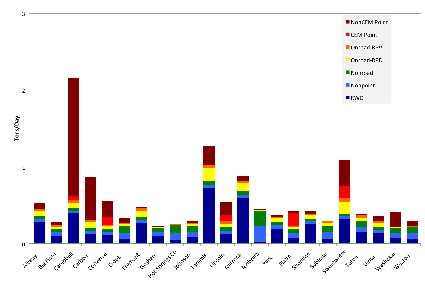
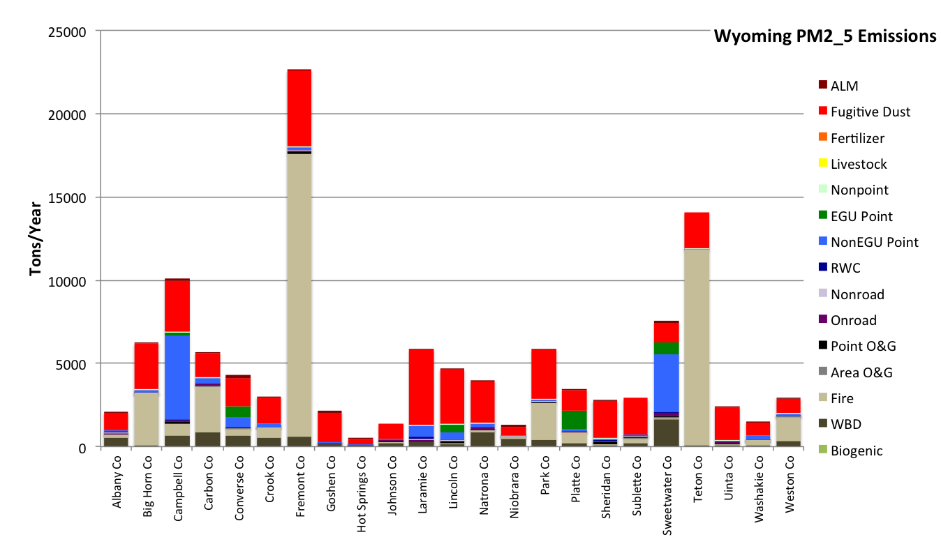
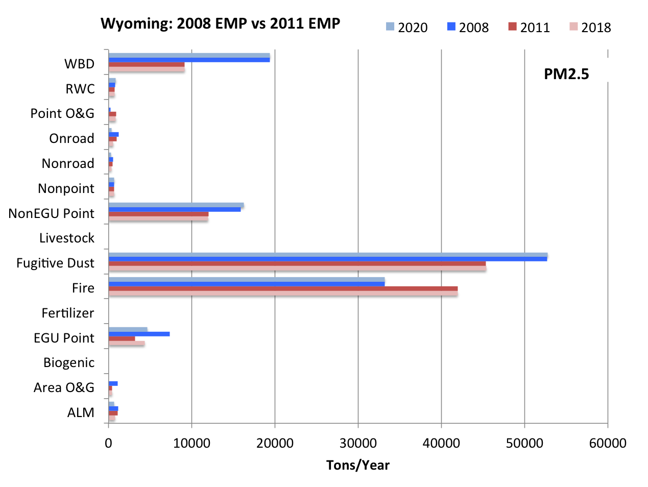
SMOKE 2011a Emissions
Introduction
The 3SAQS used the Sparse Matrix Operator Kernel Emissions (SMOKE) processing system version 3.5.1 to prepare emissions inputs for photochemical grid models (PGMs). The 3SAQS 2011 emissions modeling platform consists of data and software to estimate air emissions fluxes that best represent the conditions in the 3SAQS modeling domain during 2011. The base 2011 modeling period is annual, and included a model spin-up period from December 16 to December 31, 2011. The modeling domain includes a 36 km continental US (CONUS) domain with a 12 km nest over the western U.S. and a 4-km nest the covers the states of Colorado, Utah, and Wyoming.
The following sectors were used to represent air pollutant emissions for the 3SAQS:
- Aircraft/locomotive/marine (ALM)
- Off-road mobile (Nonroad)
- On-road mobile (Onroad)
- Non-point/Area (Nonpoint)
- Fugitive Dust
- Fertilizer
- Livestock
- Residential Wood Combustion (RWC)
- Area oil and gas (Area O&G)
- Point oil and gas (Point O&G)
- Continuous Emission Monitor (CEM) point (EGU Point)
- Non-CEM point (NonEGU Point)
- Offshore shipping (Offshore)
- Fires (Fire)
- Canada and Mexico sources (Non-US)
- MEGAN biogenics (Biogenic)
- Windblown dust (WBD)
- Sea salt
- Lightning
Details of the sources and nature of these emissions data are provided in the 3SAQS 2011 Modeling Protocol.
2011 Oil and Gas Emission Inventories and Projection Factors
| Basin | 2011 | 2020 | Description |
|---|---|---|---|
| Big Horn | xls | xls | For 2011, area source emissions were directly provided by Wyoming Department of Environmental Quality (WYDEQ) for all Wyoming counties. Emissions outside Wyoming counties are excluded from the inventory due to lack of information on activity in Montana counties for this basin. The permitted source emissions were obtained from WYDEQ for the calendar year 2011. 2011 base year emissions were projected to 2020 based on estimated changes in activity as well as control due to regulations for all counties. Activity projections were made based on statistical analysis of historical activity data for calendar year 2020. Each source category was assigned the projection estimate for the activity category to which it was most closely associated. For example, drill rig activity would be most closely associated and therefore assigned the activity projection of new spuds. Emission projections also include the effects of regulations which require controls beyond those in place in the 2011 base year. The controls were applied to only drilling and workover engines emissions as consistent with other basins. |
| Denver-Julesberg | xls | xls | 2008 WestJump survey-based emissions were projected to 2011 based on estimated changes in activity as well as control due to regulations. Activity data were obtained from the IHS database for the calendar year 2011. Each source category was assigned the projection estimate for the activity category to which it was most closely associated. For example, drill rig activity would be most closely associated and therefore assigned the activity projection of new spuds. The permitted APEN sources emissions were directly obtained from the Colorado Department of Public Health and Environment (CDPHE) for the calendar year 2011. Per agreement with the Three-State Air Quality Modeling Study (3SAQS) technical committee, for the Phase I oil and gas emission inventories, emission controls were applied to survey-based sources, but not for emissions provided by state agencies. 2011 base year emissions were projected to 2020 based on estimated changes in activity as well as control due to regulations for all counties. Activity projections were made based on statistical analysis of historical activity data for the calendar year 2020. Each source category was assigned the projection estimate for the activity category to which it was most closely associated. For example, drill rig activity would be most closely associated and therefore assigned the activity projection of new spuds. Emission projections also include the effects of regulations which require controls beyond those in place in the 2011 base year. Per agreement with the Three-State Air Quality Modeling Study (3SAQS) technical committee, for the Phase I oil and gas emission inventories, emission controls were applied to survey-based sources, but not for emissions provided by state agencies. |
| North San Juan | xls | xls | 2008 WestJump survey-based emissions were projected to 2011 based on estimated changes in activity as well as control due to regulations. Activity data were obtained from the IHS database for the calendar year 2011. Each source category was assigned the projection estimate for the activity category to which it was most closely associated. For example, drill rig activity would be most closely associated and therefore assigned the activity projection of new spuds. The permitted APEN sources emissions were directly obtained from the Colorado Department of Public Health and Environment (CDPHE) for the calendar year 2011. Per agreement with the Three-State Air Quality Modeling Study (3SAQS) technical committee, for the Phase I oil and gas emission inventories, emission controls were applied to survey-based sources, but not for emissions provided by state agencies. 2011 base year emissions were projected to 2020 based on estimated changes in activity as well as control due to regulations for all counties. Activity projections were made based on statistical analysis of historical activity data for the calendar year 2020. Each source category was assigned the projection estimate for the activity category to which it was most closely associated. For example, drill rig activity would be most closely associated and therefore assigned the activity projection of new spuds. Emission projections also include the effects of regulations which require controls beyond those in place in the 2011 base year. Per agreement with the Three-State Air Quality Modeling Study (3SAQS) technical committee, for the Phase I oil and gas emission inventories, emission controls were applied to survey-based sources, but not for emissions provided by state agencies. |
| Paradox | xls | xls | For this basin, only permitted emissions were captured as area source emissions estimation was beyond the scope of work for this study. The permitted source emissions were obtained from the Colorado Department of Public Health and Environment (CDPHE), the Uintah Department of Environmental Quality (UTDEQ) and Environmental Protection Agency (EPA) for the calendar year 2011. Activity projections were made based on statistical analysis of historical activity data for calendar year 2020. Each permitted source was assigned the projection estimate for the activity category to which it was most closely associated. Per agreement with the Three-State Air Quality Modeling Study (3SAQS) technical committee, for the Phase I 3SAQS oil and gas emission inventories, emission controls were not applied to emissions provided by state agencies. |
| Piceance | xls | xls | 2008 WestJump survey-based emissions were projected to 2011 based on estimated changes in activity as well as control due to regulations. Activity data were obtained from the IHS database for the calendar year 2011. Each source category was assigned the projection estimate for the activity category to which it was most closely associated. For example, drill rig activity would be most closely associated and therefore assigned the activity projection of new spuds. The permitted APEN sources emissions were directly obtained from the Colorado Department of Public Health and Environment (CDPHE) for the calendar year 2011. Per agreement with the Three-State Air Quality Modeling Study (3SAQS) technical committee, for the Phase I oil and gas emission inventories, emission controls were applied to survey-based sources, but not for emissions provided by state agencies. 2011 base year emissions were projected to 2020 based on estimated changes in activity as well as control due to regulations for all counties. Activity projections were made based on statistical analysis of historical activity data for the calendar year 2020. Each source category was assigned the projection estimate for the activity category to which it was most closely associated. For example, drill rig activity would be most closely associated and therefore assigned the activity projection of new spuds. Emission projections also include the effects of regulations which require controls beyond those in place in the 2011 base year. Per agreement with the Three-State Air Quality Modeling Study (3SAQS) technical committee, for the Phase I oil and gas emission inventories, emission controls were applied to survey-based sources, but not for emissions provided by state agencies. |
| Powder River | xls | xls | For 2011, area source emissions were directly provided by the Wyoming Department of Environmental Quality (WYDEQ) for all Wyoming counties. Area source emissions outside Wyoming counties for 2011 were projected from 2008 WestJump EI based on estimated changes in activity as well as control due to regulations. Activity data were obtained from the IHS database for the calendar year 2011. The permitted source emissions were obtained from WYDEQ and Environmental Protection Agency (EPA). Montana permitted source emissions were projected from 2008 WestJump EI based on estimated change in activity. 2011 base year emissions were projected to 2020 based on estimated changes in activity as well as control due to regulations for all counties. Activity projections were made based on statistical analysis of historical activity data for the calendar year 2020. Each source category was assigned the projection estimate for the activity category to which it was most closely associated. For example, drill rig activity would be most closely associated and therefore assigned the activity projection of new spuds. Emission projections also include the effects of regulations which require controls beyond those in place in the 2011 base year. The controls were applied to only drilling and workover engines emissions as consistent with other basins. |
| Raton | xls | xls | For this basin, only permitted emissions were captured as area source emissions estimation was beyond the scope of work for this study. The permitted APEN sources emissions were directly obtained from the Colorado Department of Public Health and Environment (CDPHE) for the calendar year 2011. As per the database provided by the New Mexico Environmental Department, there are no title V permitted sources on any New Mexico counties for this basin in 2011. Activity projections were made based on statistical analysis of historical activity data for calendar year 2020. Each permitted source was assigned the projection estimate for the activity category to which it was most closely associated. Per agreement with the Three-State Air Quality Modeling Study (3SAQS) technical committee, for the Phase I oil and gas emission inventories, emission controls were not applied to emissions provided by state agencies. |
| Southwest Wyoming | xls | xls | For 2011, area source emissions were directly provided by the Wyoming Department of Environmental Quality (WYDEQ) for all Wyoming counties. Area source emissions outside Wyoming counties for 2011 were projected from 2008 WestJump EI based on estimated changes in activity as well as control due to regulations. Activity data were obtained from the IHS database for the calendar year 2011. The permitted source emissions were obtained from WYDEQ for the calendar year 2011. 2011 base year emissions were projected to 2020 based on estimated changes in activity as well as control due to regulations for all counties. Activity projections were made based on statistical analysis of historical activity data for calendar year 2020. Each source category was assigned the projection estimate for the activity category to which it was most closely associated. For example, drill rig activity would be most closely associated and therefore assigned the activity projection of new spuds. Emission projections also include the effects of regulations which require controls beyond those in place in the 2011 base year. The controls were applied to only drilling and workover engines emissions as consistent with other basins. |
| South San Juan | xls | xls | 2008 WestJump survey-based emissions were projected to 2011 based on estimated changes in activity as well as control due to regulations. Activity data were obtained from the IHS database for the calendar year 2011. Each source category was assigned the projection estimate for the activity category to which it was most closely associated. For example, drill rig activity would be most closely associated and therefore assigned the activity projection of new spuds. The title V permitted sources emissions were directly obtained from the New Mexico Environment Department and Part 71 sources emissions from the Environmental Protection Agency (EPA) for the calendar year 2011. Per agreement with the Three-State Air Quality Modeling Study (3SAQS) technical committee, for the Phase I oil and gas emission inventories, emission controls were applied to survey-based sources, but not for emissions provided by state agencies. 2011 base year emissions were projected to 2020 based on estimated changes in activity as well as control due to regulations for all counties. Activity projections were made based on statistical analysis of historical activity data for the calendar year 2020. Each source category was assigned the projection estimate for the activity category to which it was most closely associated. For example, drill rig activity would be most closely associated and therefore assigned the activity projection of new spuds. Emission projections also include the effects of regulations which require controls beyond those in place in the 2011 base year. Per agreement with the Three-State Air Quality Modeling Study (3SAQS) technical committee, for the Phase I oil and gas emission inventories, emission controls were applied to survey-based sources, but not for emissions provided by state agencies. |
| Uintah | xls | xls | 2008 WestJump survey-based emissions were projected to 2011 based on estimated changes in activity as well as control due to regulations. Activity data were obtained from the IHS database for the calendar year 2011. Each source category was assigned the projection estimate for the activity category to which it was most closely associated. For example, future drill rig activity would be most closely associated and therefore assigned the activity projection of new spuds. The permitted sources emissions were obtained from the Uintah Department of Environmental Quality (UTDEQ) and Environmental Protection Agency (EPA) for the calendar year 2011. Per agreement with the Three-State Air Quality Modeling Study (3SAQS) technical committee, for the Phase I oil and gas emission inventories, emission controls were applied to survey-based sources, but not for emissions provided by state agencies. 2011 base year emissions were projected to 2020 based on estimated changes in activity as well as control due to regulations for all counties. Activity projections were made based on statistical analysis of historical activity data for the calendar year 2020. Each source category was assigned the projection estimate for the activity category to which it was most closely associated. For example, drill rig activity would be most closely associated and therefore assigned the activity projection of new spuds. Emission projections also include the effects of regulations which require controls beyond those in place in the 2011 base year. Per agreement with the Three-State Air Quality Modeling Study (3SAQS) technical committee, for the Phase I oil and gas emission inventories, emission controls were applied to survey-based sources, but not for emissions provided by state agencies. |
| Wind River | xls | xls | For 2011, area source emissions were directly provided by the Wyoming Department of Environmental Quality (WYDEQ) for Non-tribal land. Area source emissions on tribal land were projected to 2011 from 2008 WestJump EI based on estimated changes in activity as well as control due to regulations. Activity data were obtained from the IHS database for the calendar year 2011. The WYDEQ emission inventory included a small fraction fraction of wells identified as being on tribal land; adjustments were made to projected tribal emissions to avoid double counting. The permitted source emissions were obtained from WYDEQ and Environmental Protection Agency (EPA). 2011 base year emissions were projected to 2020 based on estimated changes in activity as well as control due to regulations for all counties. Activity projections were made based on statistical analysis of historical activity data for the calendar year 2020 activity. Each source category was assigned the projection estimate for the activity category to which it was most closely associated. For example, drill rig activity would be most closely associated and therefore assigned the activity projection of new spuds. Emission projections also include the effects of regulations which require controls beyond those in place in the 2011 base year. The controls were applied to only drilling and workover engines emissions as consistent with other basins. |
Results
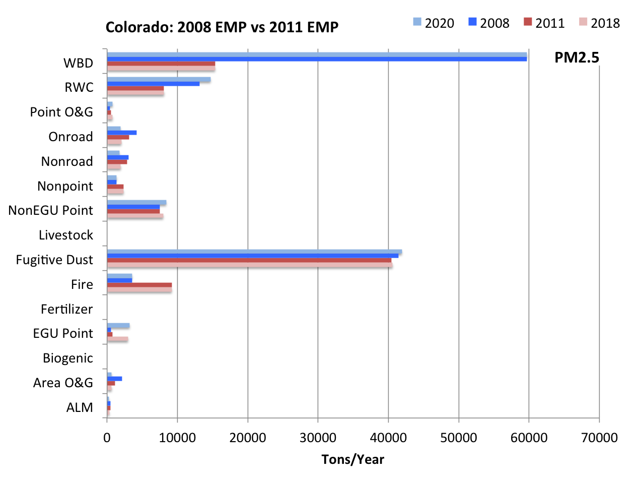
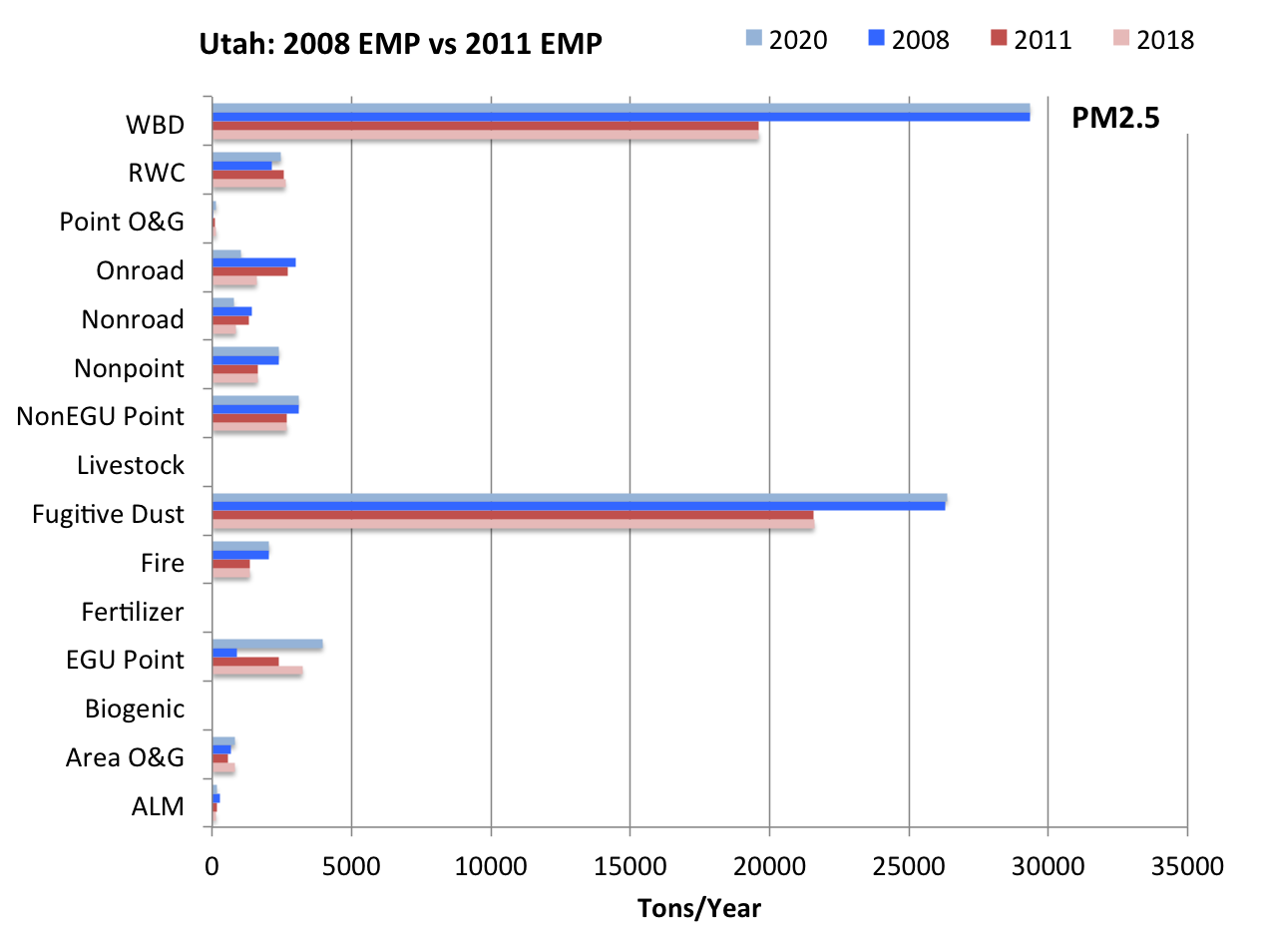
2011 version A results2011 three-state total emissions, inventory sector totals, and comparisons to the other 3SAQS modeling platforms are presented here. A complete review of the 3SAQS 2011 emissions results, including comparisons to the 3SAQS 2008 emissions is available in the 3SAQS Emissions Modeling Report
On a state total basis Colorado has the highest 2011 emissions of CO, NOx, VOC, NH3, and methane (CH4) of the three states. Wyoming has the highest 2011 emissions of SO2 and PM species.
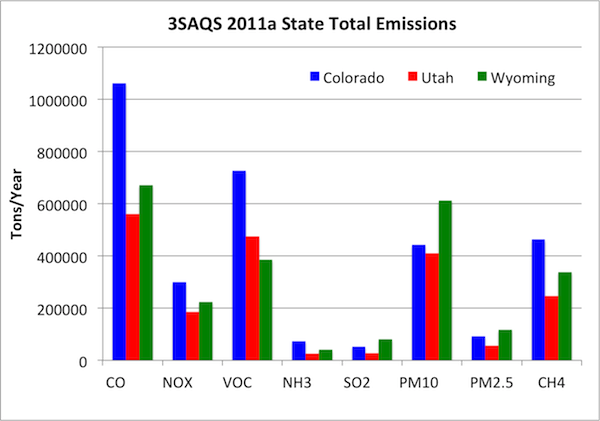
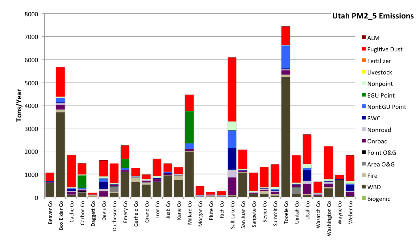
The following table includes plots that breakdown the 2011 3SAQS emissions for each inventory pollutant by sector and monthly total spatial plots on the 3SAQS 4-km modeling domain.
The high resolution maps presented here are designed to inform air quality model performance. The include the following layers:
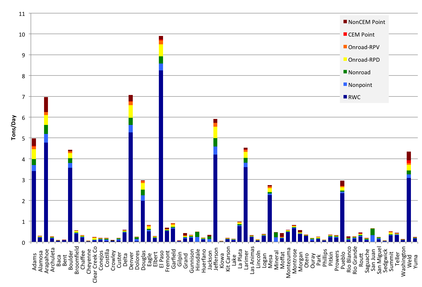
- Pie charts showing the magnitude (size of the pie) and distribution of the county-level emissions by inventory sector.
- County boundaries with county names
- Air quality monitors with the monitor station ID
- Active oil and gas wells as of January 2015
- Class I areas
- Federal lands by managing agency
Colorado: NOx, VOC, NH3, SO2, PM2.5, POC
Utah: NOx, VOC, NH3, SO2, PM2.5, POC
Wyoming: NOx, VOC, NH3, SO2, PM2.5, POC
Comparisons to 2008
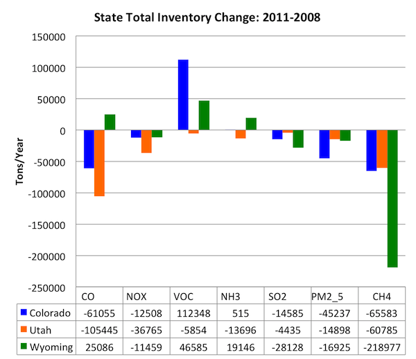 |  |
- Carbon Monoxide
- Nitrogen Oxides
- Volatile Organic Compounds
- Ammonia
- Sulfur Dioxide
- Fine Particulate Matter
- Methane
Residential Wood Combustion Sources
The model performance evaluation of CAMx simulation Base11a reveals significant positive biases (over-estimates) of organic carbon (OC) fine particulate matter (PM2.5) at urban monitors across the 4-km domain, at sites in Colorado, and in Utah. Note that there are no urban CSN monitors in Wyoming. OC has both primary and secondary sources, which will both need to be investigated to determine the cause of the poor model performance.
Residential wood combustion sources (e.g. wood furnaces, fireplaces, and wood stoves) are the largest sources of primary OC in the proximity of the monitors with the worst model performance in 3SAQS simulation Base11a.

